 |
| Landslides in the Mekong Delta directly result from climate change during which human impacts, such as sand exploitation, are too big to ignore |
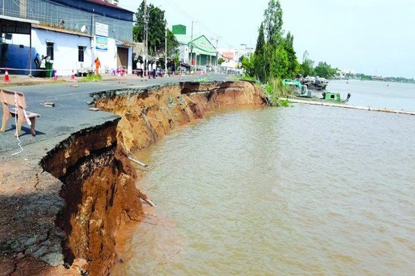
There are 564 landslide spots with a total length of over 830 kilometers in the Mekong Delta, including more than 510 riverside spots with over 560 kilometers. The figures were cited by Permanent Deputy Prime Minister Truong Hoa Binh at a working session with the People’s Committee of An Giang Province on August 21 after his inspection tour of a landslide spot in a section of National Highway 91 which runs through the province’s Binh My Commune in Chau Phu District.
Speaking with the Saigon Times on the sidelines of a media training on “Climate Change and Sustainable Energy” in the Mekong Delta from August 22 to 24, Associate Prof. Le Anh Tuan, vice rector of the Institute for Climate Change Research affiliated with Can Tho University, said the decline in alluvium and mud sand is the cause of landslide in the Delta. “In the old time, the volume of mud sand flow to the Delta was 160 million tons a year, but it is now reduced by half,” said Tuan. “Landslide and deposition were intermingled, but deposition was more dominant, so, the region was raised and expanded towards the sea. But now alluvium is dwindling, meaning less deposition and more landslide.”
Nguyen Huu Thien, an independent ecological researcher, said the Mekong Delta would receive no sand at all when 11 hydropower dams were built in the upper Mekong River. The riverbed will get deeper if sand exploitation continues. Compared with the level 10 years ago, the riverbeds of the Tien and the Hau rivers are now 1.3 meters deeper. Worse, the coastal area of the region is also prone to landslide, especially the 250-kilometer section between Tien Giang and Soc Trang provinces. “No sand flow to the Mekong Delta is already forecast,” Thien said. “What we must do is how to cope with the situation in the Mekong Delta.” The delta must be “sacrificed” if sand exploitation continues, he stressed.
Right diagnosis needed
The landslide spot on National Highway 91 section in An Giang Province’s Chau Phu District had made the headlines. Although the local authorities have made quick response by filling the spot with sandbags, all in vain.
Explaining the failure, Thien said the river section at the landslide spot is narrow and curved while the upper reach is larger. Therefore, the water flow from the upper reach must accelerate at the narrow section. The landslide riverbank is the “bay” (the concave side of the curved river section) and the opposite bank is the “promontory” (the convex side). At the curved river section, the water flow, with its straight running course, has to change its direction. A centrifugal force is therefore produced, moving the river heart, which should be in the middle of the river, close to the “bay.” Such a force also makes the water flow hit against the “bay,” raising the water level there higher than the level in the opposite riverbank. Since the water level is higher, it is pulling down by gravity. The gravity and the centrifugal force together create a twisted course. So, there are two water courses at the “bay,” one being straight and the other twisted, which together erode the lower river wall and the river bed, creating an abyss there. “When the water flow gets stronger at the beginning of the flooding season, this twisted course cuts off the lower river wall, and all the soil above sinks irresistibly,” Thien explained further.
According to Thien, in the old time there was always twisted courses at the “abysses,” which eroded the lower river wall but did not cause landslide because the water course brought alluvium and there was enough sand to absorb the water force. Today, however, alluvium is dwindling and sand is also deficient; so the water course has a greater force which can make a deeper abyss and cut off the river bank faster.
In sum, Thien pointed out five reasons for the landslide vulnerability of the river bank. First, it is soil cohesion. The looser the soil, the more vulnerable the bank. The soil of the banks of the Tien and the Hau rivers in An Giang and Dong Thap provinces is mixed with sand and thus has poor cohesion.
Second, the heavier the proper weight of the soil, the easier the sinking of the bank. The soil in localities in the upper river like An Giang Province is sandy soil, and so it is heavy, easy to sink.
Third, the higher the river wall from the bottom up, the easier the sinking of the bank.
Fourth, the pressure of the porosity of the soil. Water filled soil has strong resistance.
Fifth, the straighter the river wall, the more the danger. “For example, the river wall with soil mixed with sand must have a gradient of 30 degrees to be stable. If the current wall has a gradient of 80-90 degrees, it must break and sink until a stable gradient, say 30 degrees, is reached”, Thien said.
The options
Dr. Duong Van Ni from the Environment and Natural Resources Department of Can Tho University noted that landslide in An Giang is different from landslides in Can Tho and Hau Giang provinces. Even in the same river, landslide in the upper reach is also different from those in the middle and lower reaches. The same is with the coast; each landslide spot has its own features. “So it needs specific diagnosis to work out coping solutions. A general solution should not be the way,” Ni said.
Meanwhile, Thien argued that all coping solutions in the Mekong Delta currently cannot solve the root cause, which is the shortage of sand and alluvium. So, all solutions are temporary while landslide will continue one after another.
“The matter is a trade-off,” Thien said. “The benefit from sand exploitation and the cost and damage incurred from coping with landslides both now and in the future should be put on a balance. Which is more beneficial should be chosen.”
For the time being, Thien said the local authorities can weigh solutions to pick up the most feasible to cope with landslide. For example, a choice should be made between filling the landslide spot in National Highway 91 section with sandbags and resettlement of affected residents and construction of a bypass road. “When landslide occurs at a certain spot of the river bank, it means that the water current has chosen the most suitable spot to release its flow force. After the landslide, the water current is no longer “obstructed.” If the landslide spot is filled, the water current will be brought to obstruction, and so it must find a way out by itself,” Thien explained.
Another solution is to weigh the importance of the landslide spot and its opposite bank to direct the water course. “For example, the water course causes landslide at the National Highway 92 section which damages established houses but does not affect the farmland in the opposite bank,” Thien said. “If the farmland is less valuable, the water course can be re-directed to increase its speed and cause landslide there.” SGT
Trung Chanh
Landslides continue pulling down national road
Severe landslides continue to sweep away another section of National Highway No 91 in the Mekong Delta province of An Giang, threatening many lives along the road.
Mekong Delta suffers from coastal erosion, landslides
Provinces and cities in the Mekong Delta have suffered land erosion for decades, with hundreds of hectares being washed away along with many houses.